| Michigan
DOT's High Quality HARs Help Make "Mighty Mac" Mighty |
| Decades of
Information Broadcasts Aid Safe Mackinac Bridge
Crossings |
 |
 |
Every Labor Day, Mackinac Bridge Authority holds
an annual walk. Thousands traverse the Bridge's 5-mile
span.
Photos Courtesy of Mackinac Bridge
Authority |
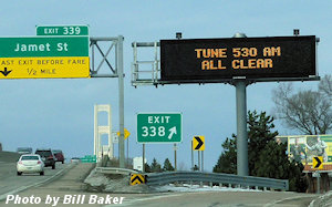
Two stations broadcast the same content on
different frequencies: north-1610 kHz; south 530 kHz.
This allows the programming to be received along
Interstate 75 for more than 30 miles. |
SAINT IGNACE, MICHIGAN: It makes sense for the
Western Hemisphere’s biggest suspension bridge to have
something else big to boast about: the Mackinac Bridge,
built in 1957 in Northern Michigan, also sports the
widest audio bandwidth of any Highway Advisory Radio
Stations operated by any department of transportation in
the 50 states.
 In
2022, the pair of Highway Information Radio Stations
(WNHC787) that bracket the Straits of Mackinac
celebrated 35 years of continuous operation. Provided by
Information Station Specialists, they are the only pair
of stations ever installed on two operating frequencies
with a 5-mile bridge in between. Moreover, they are
arguably the longest continuously-operating Information
Stations in the United States. In
2022, the pair of Highway Information Radio Stations
(WNHC787) that bracket the Straits of Mackinac
celebrated 35 years of continuous operation. Provided by
Information Station Specialists, they are the only pair
of stations ever installed on two operating frequencies
with a 5-mile bridge in between. Moreover, they are
arguably the longest continuously-operating Information
Stations in the United States.
The signals were licensed back in 1987, when only the
two original frequencies were available – 530 and 1610
kHz. Each station has the same content but is on a
different frequency: north-1610 kHz; south 530 kHz. This
allows the programming to be received along Interstate
75 for more than 30 miles – helpful to drivers should
the span be closed or restricted due to high winds,
inclement weather or a traffic incident. And then there
is the annual “Bridge Walk” – an event that closes the
bridge to all vehicle traffic every Labor Day so fans of
the "Mighty Mac" can cross it on foot.
During the past 35 years, the Mackinac Bridge Authority
has replaced the radio antennas once and has increased
the stations’ audio bandwidth to 5 kHz, after the FCC
allowed the upgrade in 2015. In 2017, after FCC approval
of new 5000 Hz filters for
TR.6000 Transmitters that effectively expands HAR
stations' bandwidth by almost 70% without the necessity
for transmitters to be recertified, the Bridge Authority
installed those upgrades too. The difference in overall
audio quality and intelligibility quickly became
apparent.
Originally, broadcast messages were spoken into a
RAM-based audio recorder that fed the two locations via
audio lines – one of which was five miles long. Brent
Garries tells The Source that today the program
originates from a Notepad/program mixer that repeats and
distributes the content to the two locations. For
talent, they have used professional announcers, MDOT
representatives and even the Bridge Authority’s
executive secretary, upon occasion.
Undoutedly, the Mackinac Bridge Authority's information
broadcasts have made the Straits of Mackinac a safer
place to cross. |
|
* * * |
| When Ice
Cometh |
| Motorist
Advisories Trigger Instantly when Conditions Get Dicey |
KINGMAN, AZ: When Hualapai Mountain Road near
Kingman, Arizona, becomes treacherous due to ice, county
officials don’t need to concern themselves with changing
the messages being broadcast on the County’s Highway
Advisory Radio Station. It all happens automatically.
Conditions on the steep, two-lane road often change
without warning. When ice is detected, pavement sensors
trigger a paging burst that is relayed to an
ALERT
AM Advisory Radio Station on the mountaintop that
instantly switches its broadcast to exclusively air
warning messages to motorists. When conditions improve,
the station’s broadcast goes back to normal, all without
operator intervention. The same wireless cue has the
capability of triggering other devices such as flashing
beacons / LED signs in concert with the radio station’s
message change.
The Information Radio service was installed by Mohave
County’s Public Works Department in 2017 to advise
commuters who use the steep mountain road that dangerous
ice is present on the pavement. A secondary goal is to
enhance safety for visitors approaching or leaving the
popular Mohave County Regional Park, which sits atop the
mountain, some 3,000 feet above the city. Hualapai
Mountain Road is the sole means of getting to the Park –
and often more importantly − back down the mountain.
Stated Mohave County’s traffic control supervisor at the
time Gregg Whaley, “This radio application proves a
successful addition to the County’s motorist information
network, in the observation of Public Works, road users
and citizens served.” |
|
* * * |
| National
Lab Threatened by Flames |
| Evacuees
Updated in Real Time by ALERT AM |
 |
 |
It's clear why Los Alamos was selected as the
site of the Manhattan Project during WWII: there are
only two roads in and out, one from the East and one
from the West.
Photos Courtesy of Philmont
Taylor, Los Alamos County, NM |
|
LOS ALAMOS, NM: Residents and workers fleeing
the flames near Los Alamos National Laboratory in 2011
listened to AM 1610 to receive special directions and
fire updates. With only two roads leading in and out of
the area, motorists had few evacuation options. The
special radio service was initiated in 2007 by Los
Alamos County’s Office of Emergency Management, with the
knowledge that some day it would be called on to protect
lives and property.
Said then Emergency Manager Phil Taylor, "Our
community's experience with the Cerro Grande fire of
2000 and the recent Las Conchas fire prompts frequent
calls to 911 asking if they need to evacuate for even
the slightest hint of smoke in the air."
Dual
ALERT AM Stations and
Flashing
ALERT Signs in Los Alamos and White Rock not only
provide motorists details about wildfires but also
traffic accidents causing road blockages, road
construction and emergency drills at the Los Alamos
National Laboratory. Two transmitting facilities cover
the population in the area, each covering 25-75 square
miles.
"Shortly after the OEM was activated, I put out an
announcement containing situation analyses and for folks
with respiratory sensitivities to consider voluntary
evacuation. The second day, I used 1610 a LOT along with
our reverse 911 to do the actual evacuation of the town
site. I had to do it in four stages, and later on, a
final 'you MUST get out NOW..." message. ...I must've
changed messages at least three times each day, with
just station ID and situational awareness messages
running on the active playlist (no weather). I'm now
broadcasting at least one fire-related message, road
closure info and weather loop. About the only
improvement I can think of right now would be ... to
stream 1610, since most folks have computers, and
even if they're evacuated out of the coverage range,
they could still listen."
Dual ALERT AM stations were first set up by EOC
personnel in 2007. Taylor described the rationale:
"Our fundamental emergency public information
requirements probably don’t differ substantially from
those of any other jurisdictions. Primarily, we’re
interested in a methodology that will allow us to
expeditiously communicate emergent information to as
many people as possible within our jurisdictional
boundaries. We have the following
constraints/challenges:
- Small, isolated, mountain community – two
roads leading in/out – deep canyons and high mesas.
- Limited commercial radio/TV coverage.
- Large daytime transient population/commuters who
work at a National Laboratory.
"Possible emergency scenarios include . . .
- Severe weather events with corresponding
school/Laboratory closures.
- Traffic accidents that interrupt normal
commutes.
- Evacuation/shelter-in-place instructions.
- Any emergency public warning/information
that needs to be disseminated RIGHT NOW.
"We used these creative methods to make citizens
aware of the station:
- Press release (he got the local press to
do an article right after the station went 'live').
- Bill-stuffer in utility bills.
- Laboratory incorporation of the press release in
their internal newsletter.
- Mention of the station by EOC personnel at every
speaking opportunity.
- The schools send info home with the kids.
- Refrigerator magnets, pens and pencils to hand
out at fairs, booths.
- Descriptive blurb with EOC email signatures."
|
|
|
[insert pic] |
| [insert date] |
| DelDOT's
Unique All-State Synched Highway Radio Service |
|
 DOVER.
DE: Delaware's Department of
Transportation has built a Highway Advisory
Radio (HAR) system that stands apart from
similar systems in the other 49 states. Due to
its limited geography and high population
density, Delaware has been able to accomplish
something not possible elsewhere: virtual
statewide signal coverage that reaches millions
of motorists. DOVER.
DE: Delaware's Department of
Transportation has built a Highway Advisory
Radio (HAR) system that stands apart from
similar systems in the other 49 states. Due to
its limited geography and high population
density, Delaware has been able to accomplish
something not possible elsewhere: virtual
statewide signal coverage that reaches millions
of motorists.
Radio World magazine, in 2019, featured
DelDOT in a national article that put a
spotlight on their system’s unique character,
i.e.,
"DelDOT Believes in the Power of Radio" by James
Careless, Apr 9, 2019.
Delaware is the only state that:
- Purchased and operates a former AM
broadcast station – rebranded “WTMC - 1380”
operating at 250 watts in Wilmington,
Delaware - as the centerpiece of their HAR
network.
- Blankets the state with a single highway
radio information program on synchronized
10-watt “repeater” stations, to create
border-to-border service on the 1380 AM
frequency.
- Operates within the conventional AM band
on Frequency 1380. (Most HAR stations are at
the end of the band (530 kHz or 1610-1700
kHz).
- Also simulcasts on FM translator WTMC
heard on 98.5 FM in the Wilmington area.
|
| * * * |
| . . . Or, you
can pay later. |
| Toll road
tells how to pay those who don't have an
account. |
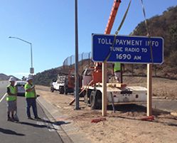 |
Workers install a sign announcing the new
Highway Advisory Radio (HAR) service on Orange
County toll roads.
Photo Courtesy of
Orange County Tollroad Corridor Agencies |
IRVINE,
CA: If you drive on a toll road in
California’s Orange County and don’t have an
account, you will be told what to do −
literally. Transportation Corridor Agencies
(TCA), which operate the County’s four toll
roads, will tell drivers via radio how to make
things right when they get home.
“Go to TheTollRoads.com. Choose the 'One-Time
Toll' option and follow the directions to pay,”
advises an announcer. “You can also download
'The Toll Roads' free mobile app to pay one-time
tolls on your smart phone.”
 Click
here to listen to a sample of the broadcast. Click
here to listen to a sample of the broadcast.
TCA began the special broadcasts in September
2014 at Windy Ridge and Catalina View toll
plazas on the 241 and 73 toll roads. The
educational campaign was planned for a year. “We
saw radio communication as an important tool to
reach toll road drivers who need to know how to
pay their tolls online. Most of our customers
are located in Orange County or the surrounding
areas and are aware that they need an account to
pay the toll. For infrequent drivers and
visitors, we needed a clear way to explain how
they can pay online after their trips. By
augmenting on-road signage with the option to
listen to the payment message while driving, we
hope to ensure that Orange County visitors have
a pleasant experience while diving the toll
roads,” said Lisa Telles, chief communications
officer for The Toll Roads.
California utilized two temporary portable
Highway Advisory Radio systems called
EventCAST from Information Station
Specialists to provide the broadcast services. |
| * * * |
| Kentucky
County Advises Motorists when NOT to Enter
Interstate |
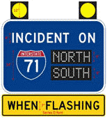 |
LA GRANGE, KY: Ramp metering controls the rate
at which drivers merge onto a busy thoroughfare.
But Oldham County, Kentucky, goes one step
farther by advising motorists when NOT to enter
their busy highway – at all!
The County, adjacent to Louisville, is bisected
by Interstate 71, a major commute route into and
out of the city. When a major incident backs up
I-71 traffic, unaware drivers often
inadvertently add to the congestion and cost
themselves time by entering the fray at one of
the County’s four interstate interchanges. Eight
wirelessly controlled, solar-powered signs
installed in advance of the associated entrance
ramps tell people to stay on the surface streets
when interstate gridlock sets in.
When activated, the signs’ 12” amber beacons
flash to attract attention; while “Stealth Sign”
LED displays can be independently selected to
advise against going north, south or both north
and south.
Designed and obtained in 2019 in coordination
with the Kentucky Transportation Cabinet, the
unique system is controlled on a VHF frequency
from Oldham County Emergency Management’s 911
Center at La Grange, Kentucky. |
|